
First hurricane paper of what promises to be a busy season
Holland and Webster in the Philosophical Transactions of the Royal Society
We find that long-period variations in tropical cyclone and hurricane frequency over the past century in the North Atlantic Ocean have occurred as three relatively stable regimes separated by sharp transitions. Each regime has seen 50% more cyclones and hurricanes than the previous regime and is associated with a distinct range of sea surface temperatures (SSTs) in the eastern Atlantic Ocean. Overall, there appears to have been a substantial 100-year trend leading to related increases of over 0.78C in SST and over 100% in tropical cyclone and hurricane numbers. It is concluded that the overall trend in SSTs, and tropical cyclone and hurricane numbers is substantially influenced by greenhouse warming. Superimposed on the evolving tropical cyclone and hurricane climatology is a completely independent oscillation manifested in the proportions of tropical cyclones that become major and minor hurricanes. This characteristic has no distinguishable net trend and appears to be associated with concomitant variations in the proportion of equatorial and higher latitude hurricane developments, perhaps arising from internal oscillations of the climate system. The period of enhanced major hurricane activity during 1945–1964 is consistent with a peak period in major hurricane proportionsIt's a hot time out there in the Atlantic today
 and the Gulf is turning into a hibatchi.
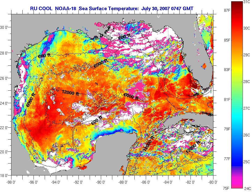
Those of you without access to Phil. Trans. can read a preprint version


20 comments:
Eli, am I correct when viewing the METEOSAT-8 imagery here that the SAL/Calima is pretty much non-existent and will play little or no role in this season?
Jack, I gotta tell you, I don't know what the SAL/Calima is. We Rabetts simply hunker down in the burrow (raised 6 feet in the air) with our carrots when the hurricane ward start.
Well I feel honored. I get to teach the great Eli something about climate. Please read my page on hurricanes here:
"HA! Look at 2006! Where are the hurricanes?"
BTW, this is a very common argument made by skeptics among the average population and astroturfing organizations.
Yikes!
http://cimss.ssec.wisc.edu/tropic/real-time/wavetrak/winds/m8split.html
ON a newspaper website I post on, someone pointed to this:
"Chris Landsea, science and operations officer at the National Oceanic and Atmospheric Administration's National Hurricane Center, said the study is inconsistent in its use of data.
The work, he said, is "sloppy science that neglects the fact that better monitoring by satellites allows us to observe storms and hurricanes that were simply missed earlier. The doubling in the number of storms and hurricanes in 100 years that they found in their paper is just an artifact of technology, not climate change."
Taken from the Washington Post ! (don't worry not fox news)
"
from:
http://thescotsman.scotsman.com/international.cfm?id=1183732007
At this stage, it is easy to see that people get confused. Anyone know anything else about Chris Landsea and his opinion of this paper?
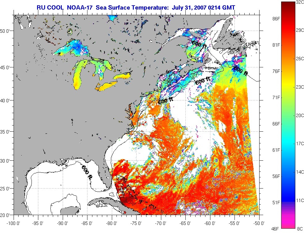
P.S., the Gulf's still cooling overnight, so this is as it says 'surface' -- changeable!
http://marine.rutgers.edu/mrs/regions/gulfmexico/sst/noaa/2007/img/070731.212.1617.n17.jpg Anyone got a link to deeper water temperature info, "loop current" info?
OK, never mind me for now, I'm found the helpful link to the preprint version at the bottom of the post. There seems to be a great deal of history involving Landsea, and I'm sure someone out there knows about it, and the competing arguments that surround this issue.
Speaking of a hot time in the NA today, did any of you catch that a tropical storm named "Chantal" developed overnight at 36.6N? That's awful far north...
Rattus Norvegicus
OK, never mind me for now, I'm found the helpful link to the preprint version at the bottom of the post. There seems to be a great deal of history involving Landsea, and I'm sure someone out there knows about it, and the competing arguments that surround this issue.
Guthrie, I haven't forgotten about you.
Chris Mooney has written a book called Storm World (I saw him speak about it in Denver last week) that covers this issue. His blog has many such posts too.
Best,
D
Do'h.
I'd forgotten about Mooney, partly because he got into this framing silliness a while back and I got fed up, because framing is just another way of saying you should speak appropriately to your audience, in ways that they will understand. Yet some people seemed to think it was really neat and important.
The warm water affects more than just storm development. NOAA put out a coral bleaching warning for part of the Florida Keys today. You can check the Coral Reef Watch site for details and thermal stress data
This is all well and good, but as soon as the auditors show that our surface heating is all due to UHI effects and poor station siting, isn't the ocean going to cool?
Yikes!
http://cimss.ssec.wisc.edu/tropic/real-time/wavetrak/winds/m8split.html
heh, thanks Hank. I dunno how I ended up at the wrong page. Although I am a bit curious why that SAL image looks nothing like any of the images on the METEOSAT-8 Satellite Images page.
So you are forecasting a busy season? Let's revisit this in November.
I think I'm forecasting an intense season. If a storm gets going everything I see out there says it will intensify strongly.
This reminds me of the old saw "live everyday as if it is your last and someday you'll be right" Predict every year is going to be the worst hurricane season evar!!1! and eventually you'll be right.
"forecasting an intense season."
does that mean a higher percentage than normal of storms above CAT 3?
or a season in tents for the storm watchers?
Or perhaps both?
There is still a lot of that dry, dusty air coming out of Africa. I also don't think that Atlantic Ocean heat content is comparable with 2005. But the season is still waiting to get started.
Meanwhile, Typhoon Usagi has just dealt a blow to Kyushu in Japan. Of course in English it translates as "Hurricane Rabbit"...
does that mean a higher percentage than normal of storms above CAT 3?
That's the beauty of the word "intense" -- this sloppy word can mean anything. I'll like to see some more predicitions from the rabbet that are 1,2,5 years out and then see if he's correct.
Otherwise he's just fitting past data into some model that shows what he wants to find out. Come on, make some predictions and we'll see if they are correct.
Post a Comment