UPDATE: After reading this see the update at the bottom for more or just go over to Neven's place
Translated from an article by Stefan Rahmstorf [] are translation notes
The media are debating if the decrease in Arctic ice is related to this winter's cold weather in Germany. This post discusses the most recent current research about this including the most important figures from relevant studies.
First, what does the unusual temperature distribution observed this March actually look like? Here is a map showing the data (up to and including March 25, NCEP / NCAR data plotted with KNMI Climate Explorer):
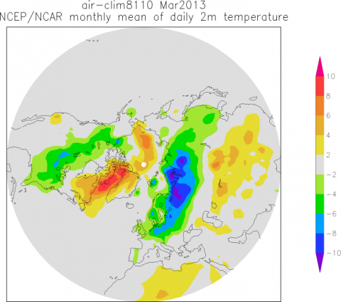
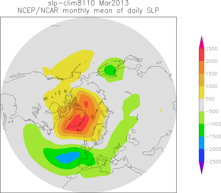
Freezing cold in Siberia, reaching across northwestern Europe, unusually mild temperatures over the Labrador Sea and parts of Greenland and a cold band diagonally across North America, from Alaska to Florida. Averaged over the northern hemisphere the anomaly disappears - the average is close to the long-term average. Of course, the distribution of hot and cold is related to atmospheric circulation, and thus the air pressure distribution. The air pressure anomaly looks like this:
There was unusually high air pressure between Scandinavia and Greenland. Since circulation around a high is clockwise [anticyclone], this explains the influx of arctic cold air in Europe and the warm Labrador Sea.
Arctic sea ice
Let us now discuss the Arctic sea ice. The summer minimum in September set a
new record low, but also at the
recent winter maximum there was unusually little ice (ranking 6th lowest - the ten years with the lowest ice extent were all in the last decade). The
ice cover in the Barents sea was particularly low this winter. All in all until March the deficit was about the size of Germany compared to the long-term average.
Is there a connection with the winter weather? Does the shrinking ice cover influence the atmospheric
circulation, because the open ocean strongly heats the Arctic
atmosphere from below? (The water is much warmer than the overlying cold polar air.) Did the resulting evaporation of sea water moisten the air and thus lead to more snow? These questions have been investigated by several studies in recent years.
Petoukhov and Semenov, JGR 2010
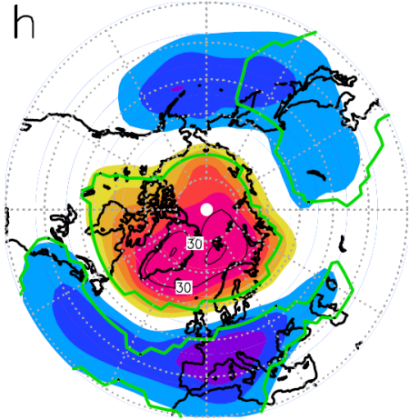
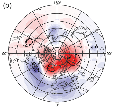
These two scientists from the Potsdam Institute and the Leibniz Institute of Marine Sciences in Kiel used the ECHAM5 atmospheric model. As a boundary ondition in a series of simulations they reduced ice cover in the Barents and the adjacent Kara Seas. With a medium sized reduction in ice volume similar to what we now see they calculated the anomaly in the pressure distribution shown below (they also examined what would happen for a complete loss):
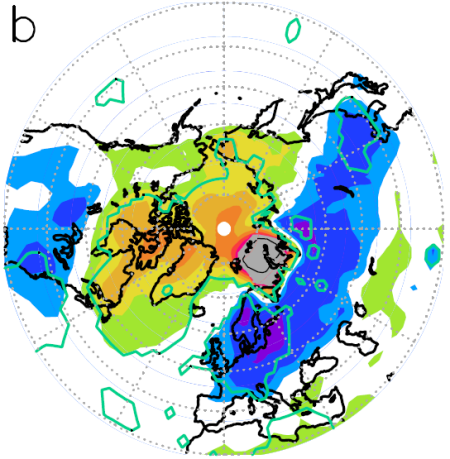
Thus, abnormally high air pressure between Scandinavia and Greenland. Leading to the following temperature anomaly:
Cold from Siberia to Western Europe and a heat bubble centered on Labrador - quite similar to the temperatures this March.
Jaiser et al., Tellus 2012
Our colleagues from the Alfred Wegener Institute, together with U.S. researchers, examined the question of whether one finds this relationship in observational data. For this purpose, they investigated the correlation between the distribution of air pressure and ice cover in an analysis of their covariance. They concluded:
Our analysis suggests that Arctic sea ice concentration changes exert a remote impact on the large-scale atmospheric circulation during winter
The following graph from this work shows how the distribution of air pressure in winter changes between phases of low and high fall-ice cover in the Arctic:
You can see that low ice cover correlates with high pressure in the Arctic winter, again between Scandinavia and Greenland - just as in the model calculations of Petoukhov and Semenov. (Jaiser et al do not show temperature maps)
Liu et al., PNAS 2012
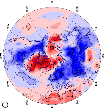
Next on the dance card is a study which appeared shortly thereafter by researchers from the U.S. and China, which approached the problem from both sides: model simulations and data analysis. The following map shows the linear regression between less ice cover in autumn and the temperature in winter:
Again, these temperature anomalies are similar to the two shown above, the temperature map for this March and that from the model of Petoukhov and Semenov.
An observed correlation (as in this diagram and in Jaiser et al.) is still not a causal connection, therefore Liu et al. also made a series of model calculations, but with a different model (the American model from NCAR). Further, they calculated a larger ensemble (20 runs with varying initial
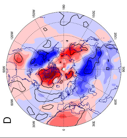
conditions), which makes the results statistically more robust. As a boundary condition in the model they took the observed reduction of the ice cover in the Arctic and calculated ensembles with or without the ice decrement. The result of these simulations for the temperature is as follows:
Again cold in Siberia and Europe, warmer over the Labrador Sea, and a cold band across North America. From the model, we know that it's not just a correlation, but a causal relationship: In the model setting the prescribed ice cover results in cold temperatures over Europe, just as in Petoukhov and Semenov. The associated air pressure maps are also similar.
Liu et al. also have dealt with whether alternatively the Arctic Oscillation (AO) or the North Atlantic Oscillation (NAO) could explain the temperature anomalies. They showed that these natural oscillations lead to different spatial patterns and inter-annual fluctuations - they ruled out the AO and NAO as causes.
They also have examined the relationship with snow and come to the conclusion that additional open water in the Arctic humidifies the air, leading to increased snowfall. The snowpack is important because even the strong March sun can hardly heat up snow-covered land; the white surface simply reflects the sun's rays. According to Liu, et al.
We conclude that the recent decline of Arctic sea ice has played a critical role in the recent cold and snowy winters.
However, the taz quoted [German paper] yesterday the spokesman of the German Weather Service [DWD in German] as saying that if there was a direct relationship with the sea ice cover, the entire winter would have to be very cold in Germany. I think this trivial argument with which he would like to wipe from the table the climate research results shown above is pretty embarrassing for the DWD. Of course open water in the Arctic does not prevent stochastic weather variability. There will always be warm and cold periods. In all these studies it comes down to changing probabilities in the prevailing weather patterns: Petoukhov and Semenov estimate that the probability of cold winter extremes could triple, that is even in the
Abstract. One wonders whether the DWD representative has read the relevant studies at all - and if not, why he feels the urge to comment on them in the media. Unfortunately, it has a certain tradition that meteorologists dealing with weather, are not familiar with climate science.
In my view, the above studies provide strong evidence for a link between Arctic ice loss due to global warming, more frequent winter high pressure, especially over the Atlantic-European part of the Arctic, and an associated influx of cold air to Europe. As we have often seen in recent winters - for example in a spectacular way in the first half of February 2012.
Still this is still not settled science - the studies are relatively new and need to be discussed intensively in the professional community and confirmed by further research, or perhaps called into question. This is the normal process of scientific debate, through which at the end findings are distilled which are robust and widely accepted, such as the fact that our
emissions of greenhouse gases warm the climate.
P.S. (29.3.)
I see now that
the climate lie detector has put its finger on the beautiful article in Welt Online, which a few days ago once again
presented the proverbial "Russian scientists who predict an ice age" warning of a "freezing pig cycle". There is no better way of actually disproving that solar fluctuations are to blame, when even diehard "climate skeptics" can not find any more respectable arguments. This time, even sponsored by Gazprom (for real!). Anyone interested in the subject of climate and sun: could read
What role does the sun play? [Maybe Eli will translate some day for some carrots]
References
Jaiser R, Dethloff K, Handorf D, Rinke A, Cohen J (2012) Impact of sea ice cover changes on the Northern Hemisphere winter atmospheric circulation.Tellus Series A-Dynamic Meteorology and Oceanography 64th doi: 10.3402/tellusa.v64i0.11595
Liu JP, Curry JA, Wang HJ, Song MR, Horton RM (2012) Impact of declining Arctic sea ice on winter snowfall. Proceedings of the National Academy of Sciences of the United States of America 109 (11) :4074-4079th doi: 10.1073/pnas.1114910109
Petoukhov V, Semenov VA (2010) A link between reduced Barents-Kara sea ice and cold winter extremes over northern continents. Journal of Geophysical Research-Atmospheres 115th doi: 10.1029/2009jd013568
UPDATE: R Gates at
Neven's Sea Ice Blog
There are certainly two dynamics at play in the "weirding" of this winter's weather, but before discussing them, it would probably be good to understand that we are in a new regime of climate and therefore weather patterns, and thus, the weather is only weird compared to some former regime. In other words-- weird is the new norm, and it will be weird in the future not to have blocking patterns and associated extremes that come with climate change.
But back to the two big dynamics at work in this winter's NH winter. The first is of course the big SSW [Sudden Stratospheric Warming] event that took place in early January. This event was not unlike the big SSW events of 2009 and 2006. The polar vortex was shattered and the normal westerlies over the Arctic reversed and cold air from the east has been generally circulating over N. Europe for several months. The SSW event from January, in addition to breaking down the vortex and warming the stratosphere over the Arctic, brought downwelling air actually all the way from the mesosphere down into the stratosphere and created higher pressure all the way down to the troposphere. . . . In short, the SSW event from January has had lingering repercussions far beyond the original rapid stratospheric temperature spike. [continued]






 Keith's 8 Feb note: Its is rather odd that Aviation Week would make this statement about Worden's personal "involvement" given that his name is not even contained in the letters (linked below). What is especially baffling is how Rep. Wolf, an avowed China hater, could think that a former Brigadier General - someone who worked throughout the Cold War to defend the U.S. against potential foes such as China, would suddenly - and knowingly - allow his employees to leak things to China or to condone such behavior.


